/INIGRAV
Block Format Keyword Defines initial state from hydrostatic pressure due to gravity loading.
Format
| (1) | (2) | (3) | (4) | (5) | (6) | (7) | (8) | (9) | (10) |
|---|---|---|---|---|---|---|---|---|---|
| /INIGRAV/inigrav_ID/unit_ID | |||||||||
| inigrav_title | |||||||||
| grpart_ID | surf_ID | grav_ID | |||||||
| Pref | Bx | By | Bz | ||||||
Definition
| Field | Contents | SI Unit Example |
|---|---|---|
| inigrav_ID | Initial gravity loading
identifier. (Integer, maximum 10 digits) |
|
| unit_ID | Optional unit identifier. (Integer, maximum 10 digits) |
|
| inigrav_title | Initial gravity loading
title. (Character, maximum 100 characters) |
|
| grpart_ID | Group of part identified. If non defined
(0), initial state is applied on all solid PARTs. Default = 0 (Integer) |
|
| surf_ID | (Optional) Free surface identifier. If not defined, basis point is read. (Integer) |
|
| grav_ID | (Mandatory) Gravity card identifier
used. (Integer) |
|
| Pref | Reference pressure on the reference
surface. (Real) |
|
| Bx | Basis point X-coordinate (used only if
surf_ID=0). (Real) |
|
| By | Basis point Y-coordinate (used only if
surf_ID=0). (Real) |
|
| Bz | Basis point Z-coordinate (used only if
surf_ID=0). (Real) |
Example (Water Hydrostatic Pressure)
#---1----|----2----|----3----|----4----|----5----|----6----|----7----|----8----|----9----|---10----|
/UNIT/1
unit for load
#              MUNIT               LUNIT               TUNIT
                   g                  mm                  ms
#---1----|----2----|----3----|----4----|----5----|----6----|----7----|----8----|----9----|---10----|
/INIGRAV/1/1
hydrostatique pressure - “ sea level : {Z=0} where Pref=0.101325 MPa
#GRPART_ID   SURF_ID   GRAV_ID
         0         0         1
#               Pref                  Bx                  By                  Bz
            0.101325                   0                   0                   0
#---1----|----2----|----3----|----4----|----5----|----6----|----7----|----8----|----9----|---10----|
/GRAV/1/1
Terrestrial gravity field
#funct_IDT       DIR   skew_ID sensor_ID  grnod_ID                      Ascale_x            Fscale_Y
         2         Z         0         0         5                             0            -0.00981
#---1----|----2----|----3----|----4----|----5----|----6----|----7----|----8----|----9----|---10----|
/FUNCT/2
unity
#                  X                   Y
                   0                 1.0
             1000000                 1.0
#---1----|----2----|----3----|----4----|----5----|----6----|----7----|----8----|----9----|---10----|
#enddata
Comments
- Gravity value and direction are read from /GRAV card, then grav_ID value is mandatory.
- The surface identifier provides the sea level. surf_ID can either be a /SURF/PLANE (Figure 1) or any other user surface describing the air-water limit (Figure 2). If surf_ID is not provided, then planar surface is assumed by using B=(Bx,By,Bz) as basis point and gravity vector as surface normal.
- Pref is the reference pressure at sea level. Above the surface pressure is decreasing and below the surface pressure is increasing.
- This keyword is computing for each cell in group of part provided by grpart_ID. This initial density is such as pressure changed is where is the signed distance from the sea level. Distance from sea level is computed using cell centroid.
- Mathematical model is such as for each
cell
. This model is only valid if material type is not changing
along the distance (constant reference density).For example: only air above the surface and only water below the surface. Introducing an immersed body into water would require running a computation to solve hydrostatic state in the immersed body.
Figure 1. Initial pressure computed from sea level with planar surface 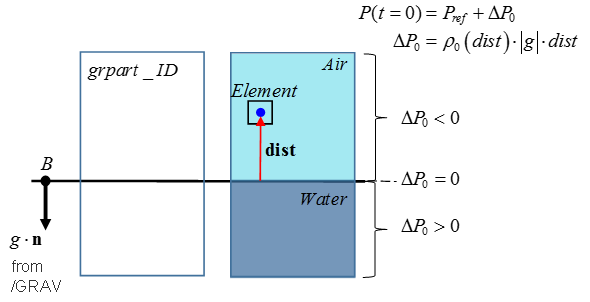
Figure 2. Initial pressure computed from sea level with user surface 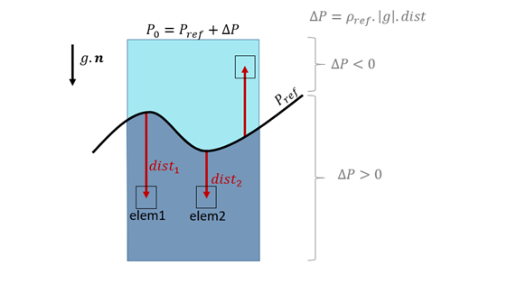
- If /INIVOL option is used to initialize volumetric fraction with LAW51 then reference density is automatically computed from initial volumetric fractions.
- Currently only compatible with hydrodynamic laws 3, 4, 6, 37, 49, 51, and 151.
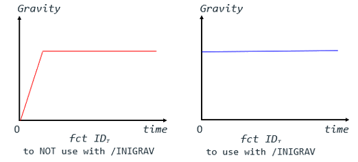
- The grav_ID card must reference a gravity
/GRAV with a constant gravity function
fct_IDT from t=0; or, the function
can be left blank and the constant gravity value defined in /GRAV,
FscaleY.
Figure 3.